In the southern hemisphere, that exact same time marks the Spring Equinox.
Here are 3 predictions for the fall season in southern Wisconsin, which lasts until December 21st:
1. Fall colors will be spectacular
Summer weather -- both during and after the growing season -- has a great impact on the color display we see in the fall. This summer's conditions have been perfect:
- A lot of rain during the height of growing season (July). At my house, we recorded 11.5 inches of rain in July, although the Madison airport recorded a bit less than 7 inches.
- That was followed by an unusually dry, cool and sunny period, particularly in the last half of August and early September.
The timing of those conditions is nearly perfect for an excellent color show. The dry, cool nights of late August allow chlorophyll to be blocked from the leaves of the tree, giving the vibrant oranges, reds and yellows an opportunity to take over.
There is one caveat here: some places that received too much rain mid-summer (the southwestern corner of the state, for instance) could have problems with fungus and early dropping of brown, dead leaves. Location is everything.
There is one caveat here: some places that received too much rain mid-summer (the southwestern corner of the state, for instance) could have problems with fungus and early dropping of brown, dead leaves. Location is everything.
The August cool spell may also result in a slightly earlier peak than normal -- perhaps the first week of October (instead of the middle of the month).
2. In the short term, temperatures remain mild, but...
The 3-week period of unusually cool weather has been replaced by very summery conditions. While not technically an "Indian Summer," which by definition can only occur in November, our recent warm spell certainly feels like summer in Wisconsin.
In the short term, that trend will continue. The same strong high pressure in the eastern U.S. that's keeping recent hurricanes Jose (and probably Maria) off the coast creates a ridge that southern Wisconsin benefits from. Winds rotate clockwise around high pressure, bringing us a southerly flow that keeps temperatures warm.
Models now expect a new pattern to take shape in early October, and it won't likely relent very soon. Look for a normal or below-average October, which will likely produce our first hard freeze. Follow me on Facebook for the latest in medium-range weather observations.
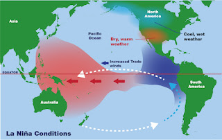
3. Developing La Nina may result in an earlier, harsher winter
La Nina -- the cooling of sea surface temperatures in the equatorial Pacific Ocean -- seems to be taking shape somewhat rapidly. Weather models are now suggesting that a moderate La Nina may be in effect by November or December.
Generally, La Nina results in colder, snowier winters in our part of the country (as opposed to milder winters sponsored by El Nino). This is because La Nina promotes certain storm tracks that are conducive to heavier snow events (including the mother of all winter storm tracks, the Texas panhandle hook).
Last year's winter essentially only lasted a month (which blew my Winter Outlook all to pieces). December was very snowy, but the rest of the winter was, by and large, relatively mild. El Nino was in place last winter.
This year, I'd expect our first significant snowfall to occur around or before Thanksgiving. That would be two-thirds of the way into the fall season.
Have questions? Post them here or on Facebook and I'll do my best to answer!
~Scott


No comments:
Post a Comment